


Geothermal energy, natural hydrogen, critical minerals, wind turbines… Energy transition means exploring the subsoil. And efficient, profitable and ‘clean’ exploitation means the need for a detailed knowledge of the Earth’s subsurface. This is possible thanks to geophysical methods, techniques that make it possible to obtain an indirect image of the subsoil and interpret it. Explanation.
How can you locate a site suitable for the installation of a geothermal power plant? How can you identify the geological structures most favorable to the production of natural hydrogen? How can you find out about the best reserves of strategic minerals essential to the energy transition? Thanks to geophysical methods!
“These methods are essential to provide geologists and geophysicists with the information they need to understand the subsurface. Ultimately, it’s about defining precisely where to drill,” explains Fabien Cubizolle, geophysical engineer and head of geophysics at LookUp (read interview).
Geophysics is a science that makes it possible to image the physical properties of the subsurface, in particular to determine how these properties are distributed in the underground space. “By interpreting them, we can locate the geological layers and study their structure. In the context of renewable energies, such as geothermal energy or natural hydrogen, they will make it possible to detect anomalies that may indicate the presence of fluids, a particular geological body or a favorable geological context,” continues the geophysicist.
Exploiting the physical properties of the subsoil
The subsoil is made up of rocks of different types with various physical properties, organized in the form of sedimentary layers or magmatic intrusions, sometimes transformed, deformed, or even traversed by faults (fractures) or aquifers (porous rock containing water).
To study and characterize these geological structures, different physical properties of the rocks can be exploited:
- density and elasticity, which are directly related to the speed of propagation of seismic waves;
- conductivity and resistivity, i.e. their ability to conduct or, on the contrary, to oppose an electric current;
- magnetic susceptibility, i.e. their ability to be magnetized (this susceptibility reflects the content of ferromagnetic minerals in the rocks, such as magnetite);
- capacity to vary the gravitational field, with positive anomalies being linked to the presence of low-density rocks or cavities, while negative anomalies are linked to the presence of denser rocks or metallic deposits;
- electromagnetic conductivity, which is influenced by the presence of underground water or aquifers, conductive minerals, and also hydrocarbons.
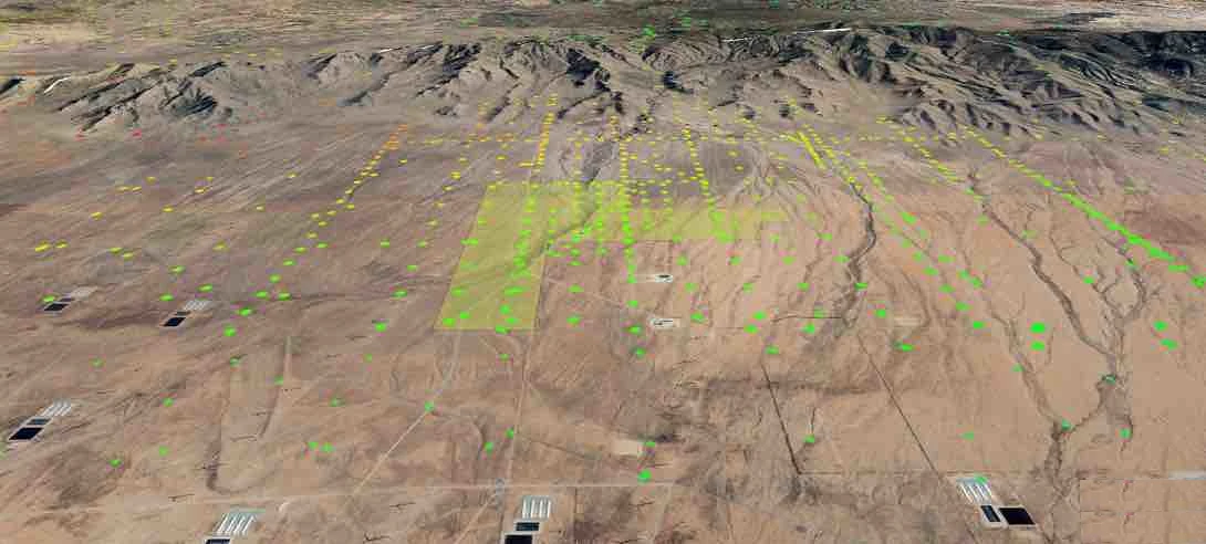
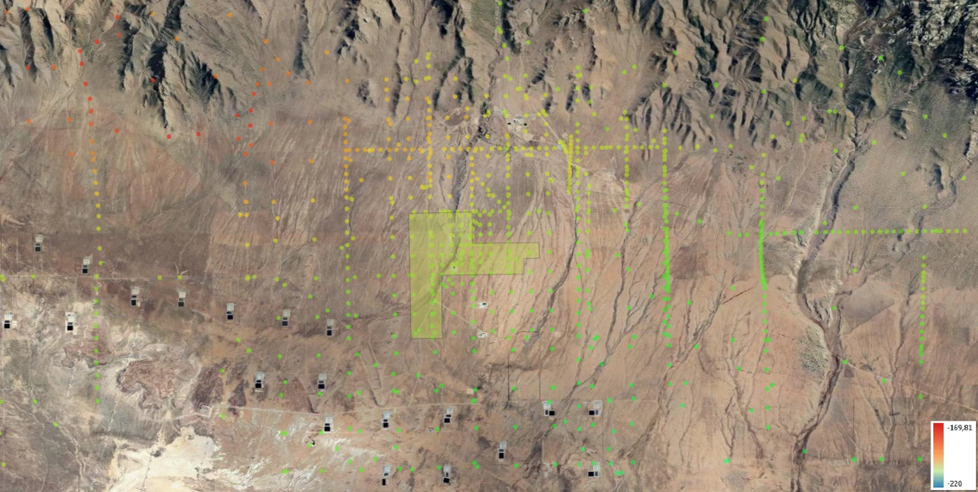
Projection of resistivities (Ω.m) measured by magnetotellurics over the FORGE Utah geothermal field (boxed in yellow)
A respectful approach to the subsoil
The measurements of these different properties can be carried out in a way that respects the environment. Geophysical methods are in fact:
- “non-intrusive”: they are applied from the surface, so do not involve drilling;
- “non-destructive”: they do not alter the properties or structure of the subsoil.
Collecting data
The first step is to collect subsoil data – this is called an “geophysical acquisition campaign”. It involves the use of two types of methods:
- “Passive” methods: use of signals naturally emitted by the earth (seismic waves linked to plate tectonics) or the sun (electromagnetic waves such as solar winds that cause the famous aurora borealis);
- “Active” methods: use of signals from “artificial” sources, such as an electric current emitted by electrodes, seismic waves emitted by vibratory trucks, an electromagnetic field emitted by antennas, etc. Depending on the case, the signals are generated from the ground surface, from underground (at wells) or from the air (drones, planes, satellites).
These waves will pass through the various geological layers and return to the surface to be recorded by sensors positioned on the ground surface or on aerial structures. The different properties of the rocks will influence the propagation of these waves in different ways.
By capturing these waves once they have passed through the underground structures, it is possible to obtain detailed information about the geological formations and deduce the architecture of the subsoil. It is exactly the same principle as medical ultrasound.
Some examples of geophysical methods
Seismic methods
- Seismic reflection makes it possible to measure the travel time of seismic waves passing through the subsoil and to deduce the density of the rocks. These waves penetrate and are reflected at the interfaces between the different geological levels, which changes their speed. By measuring these variations in speed, it is possible to deduce the structure of the sedimentary layers, in particular to detect faults in them.
- Seismic refraction is based on the same principle as seismic reflection, but this time it is based on measuring the speed of the waves which, before reaching the surface, propagate along the interfaces between the geological levels. It makes it possible to measure the slope and depth of the geological layers, and to determine the nature of the rocks.
Potential methods
- Gravimetry consists of measuring variations in the gravitational field. It involves identifying “anomalies” (positive or negative) related to variations in the density of the rocks in the subsoil. This method makes it possible to delimit geological structures and detect the presence of a cavity or fluid (hydrothermalized zones).
- Magnetism (or magnetometry) consists of measuring variations within the Earth’s magnetic field using a magnetometer. It can be used to detect ferromagnetic metals (iron, steel, nickel, etc.) or magnetic contrasts, related for example to the presence of faults or folds.
Electrical methods
This consists of injecting an electric current into the ground using a pair of electrodes and measuring the potential difference using another pair of electrodes. These will make it possible to identify areas rich in minerals, but also to locate aquifers.
Electromagnetism
These are methods such as CSEM (Controlled Sources ElectroMagnetic) or magnetotellurics. They consist of recording a variation in the electromagnetic field linked to the resistivity or, on the contrary, the conductivity of the rocks in the subsoil. These methods make it possible to deduce the magnetic nature of the underground rocks and to identify the presence of fluids or minerals.
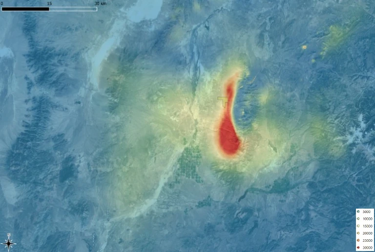
Complete Bouguer anomaly in mgal (gravimetry) on the geothermal field of FORGE Utah
Integrating the different methods to reduce uncertainties
Each of the geophysical methods provides data corresponding to a single physical property of the subsurface rocks, and each has its own resolution. These data, interpreted individually, will only provide a partial overview of the nature of the geological formations. On the other hand, by aggregating them in order to interpret them jointly, it becomes possible to remove certain ambiguities – and therefore reduce uncertainties – and obtain a geological model that is both robust and precise.
By Véronique Molénat.
Nota bene: All data produced at the Utah FORGE site is available on the Geothermal Data Repository website (https://www.gdr.openei.org/).